|
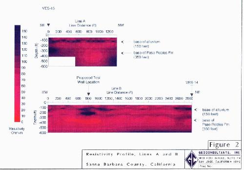
Line A is orthogonal to Line B, so that the NW end
of Line A joins the SW end of Line B. Line A is
roughly aligned across the presumed electrical strike of the
formations and Line B is roughly parallel to the strike.
Data from existing wells and some vertical electrical
soundings (VES) completed in the area were used to
constrain the geoelectrical model.
A
test hole was completed at the proposed well location, and
pre-drilling interpretation of the profile (image) compares
favorably with the results. The base of the
saturated younger and older alluvium was found at about the
150-foot depth. Clay and sand of the Paso Robles Formation
were logged to a depth of 200-250 feet. Below 250 feet
decreasing sand and increasing amounts of siltstone (material
of low electrical resistivity) were noted to the total depth
explored (about 300 feet) in the test hole.
The
test hole was not carried deeper because the Stratagem profile
shows that only materials of relatively low resistivity
(either siltstone or materials having poor quality water) are
present to at least 600
feet |